

The FIRST Big Battle Over Districting
The FIRST Big Battle Over Districting
Class 4: Malapportionment, and How Baker v. Carr Upended the Nation

Does today’s gerrymandering infuriate you? Politicians rigging districts so that they stay in power and can never be held accountable, and warping democratic representation overall? (You’ve probably noticed that it sure infuriates me.)
Well, what if instead of crazy-shaped and rigged districts, politicians sat in districts of totally different population sizes. Say, a large city of 800,000 people comprises a Congressional or statehouse district; and somewhere else in the same state, a number of small towns totalling 150,000 people comprise their own Congressional district. Then imagine that there are many other districts with equally small populations. Think of all the consequences such a system would lead to.
Not that long ago, that scenario was actually the status quo of American politics. The legal term for the issue was malapportionment. And for years, as with gerrymandering today, the Supreme Court said there was nothing to be done about it…until it changed its mind, and in doing so, changed the nation.
It all came to a head in a historic case that grew into an epic battle—among some of our nation’s most famous justices, and later, among politicians. And that case, Baker v. Carr, ultimately sparked a revolution that reshaped American politics.
In fact, Earl Warren considered Baker the most important of his tenure as Chief Justice. (Yes, that means he considered it more important than even Brown v. Board of Education).
You’ll soon see why….
What was Malapportionment?
If gerrymandering is the act of intentionally drawing districts that predetermine election outcomes, thwart representation and accountability, and alter the political balance of power, think of malapportionment as the opposite means to achieve the same end.
Opposite in that the districts involved were not redrawn…for decades on end. They weren’t changed at all.
After the turn of the century, in state after state, even as populations exploded and shifted—and diverse, urban areas grew in particular—district maps from a bygone era simply went unaltered. Congressional and state legislative districts remained locked into place, one decade after the next. And those seated comfortably in power in those districts simply refused to update them despite dramatic changes in population beneath their feet.
This left some districts, largely in urban areas, far larger in population but still represented by a single officeholder; and other districts, in rural parts of states, lightly populated, yet they too continued to be represented by a single officeholder. Over time, those dramatically different-sized districts presented a huge problem to representative democracy.
To understand the extent of the problem, let’s get specific. Let’s look at Illinois.
Here is what the Illinois map looked like in 1901….and still in 1946.
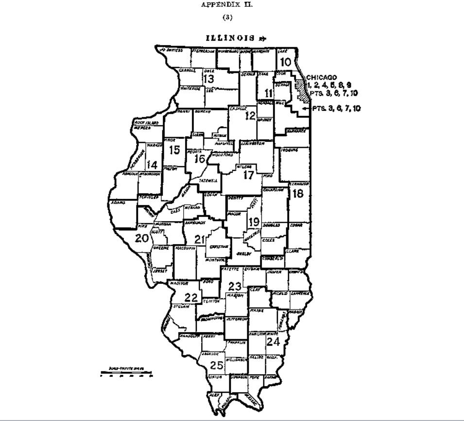
From the map alone, it’s hard to see the problem — in fact, these districts look a lot cleaner than most of the districts in today’s wildly gerrymandered world.
So the following slide (laying out the populations of the 26 districts in the 1940s) demonstrates the problem more clearly:
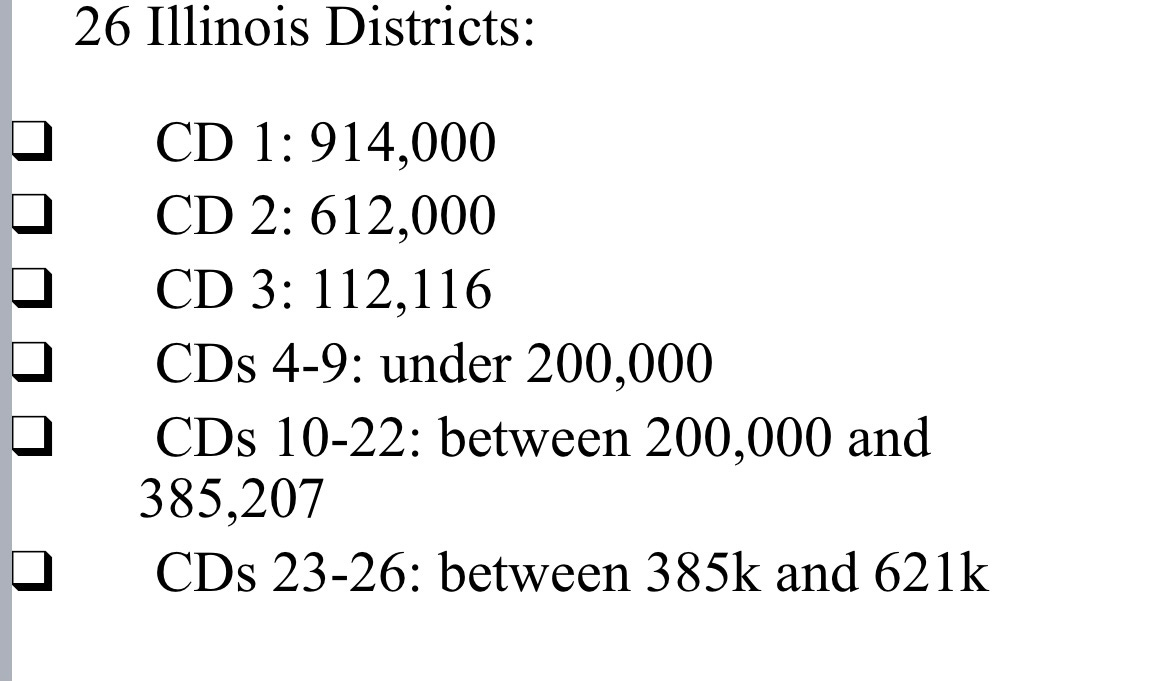
That’s right, while a single Chicago district included more than 900,000 citizens, and another had 612,000, a rural Illinois district represented only 112,000 citizens. And many others were under 200,000. And no matter the size, each of these districts was represented by a single member of Congress.
So when it came to representation in Congress, that meant that a voter’s vote in that highly populated district carried 1/9th the weight of the smallest district. And of course, the undervalued votes were disproportionately those of urban and Black voters.
And when you add up all these voters and districts across the state of Illinois, this meant that rural, largely White communities were represented in Congress by a proportion of representatives far greater than their proportion of the population, and far greater, relatively, than the urban, racially diverse communities of major cities. This also was one reason (alas, there were so many) that so few officeholders of color walked the halls of Congress or statehouses.
As the decades passed, almost all states followed the same path as Illinois. Politicians in power kept old maps frozen in place, even amid dramatic changes in states’ populations. By mid-century, the nation’s entire political system was anchored in intensely malapportioned districts everywhere, which grew worse by the year.
It was the never-challenged status quo, so it just kept getting worse.
And then someone challenged it.
1. Colegrove v. Green (1946)
In 1946, the Court came face-to-face with the Illinois map above. And in a case called Colegrove v. Green, the Court not only declared that it would not strike down the map, the Court ruled that it had no business considering cases of this type at all.
Justice Felix Frankfurter’s opinion echoed much of the reasoning from the Giles case from last week (and will also sound a lot like recent cases where the Roberts Court has decided NOT to take on the issue of partisan gerrymandering). According to Frankfurter, for a variety of reasons, federal “Courts ought not to enter this political thicket.” Disputes over districting and broader issues of governance—a “wrong suffered by Illinois as a polity”—were for legislatures and Congress to work out, not courts. Courts had no basis to adjudge districting disputes, lacking both Constitutional power and institutional expertise to correct them.
It’s for the people and elected leaders to solve this problem, he declared: “The remedy for unfairness in districting is to secure State legislatures that will apportion properly, or to invoke the ample powers of Congress.”
Not judges. “It is hostile to a democratic system to involve the judiciary in the politics of the people.” Frankfurter worried that if the Court involved itself in such highly charged political matters and “party contests,” it would destroy its credibility in all matters. (This approach fit into his broader theory of judicial restraint that had reversed the prior era of a conservative Supreme Court repeatedly striking down New Deal laws.)
Another FDR appointee, Hugo Black, dissented. Malapportionment—and the dilution of certain voters’ votes—clearly implicated the Equal Protection Clause: "No one would deny that the equal protection clause would also prohibit a law that would expressly give certain citizens a half-vote and others a full vote.” Just as a hypothetical law “requiring that all…26 Congressmen be elected by the citizens of one county” would be a denial of the right to vote. He concluded that while districting cases are no doubt '“political,’ “it is a mere ‘play on words’ to refer to a controversy such as this as ‘political’ in the sense that courts have nothing to do with protecting and vindicating the right of a voter to case an effective ballot.”
Remember these two arguments: they will reappear going forward, including recently. But for the time being, extreme malapportionment and its consequences would continue unabated with no court intervention.
2. Gomillion (1960)
Fourteen years later, the Court weighed in on a different type of districting case. Frankfurter again wrote the opinion, this time for a unanimous court. But in this case, he struck down a state legislature’s alteration of a local “map.”
Charles Gomillion was a long-time professor and dean of students at the revered Tuskegee Institute in Macon County, Alabama. Dean/Professor Gomillion was also a voting rights champion. He and others led registration and voting drives that, over the years, greatly increased the Black share of registered voters in the City of Tusekegee—reaching around 40% of the City and 33% of County.
As so often happened, that growing Black electorate triggered a response, and in this case, it came from the Alabama legislature which in 1957 passed a bill that redistricted the City of Tuskegee. As the diagram below shows (and this map was displayed before the Court in oral argument), the bill redrew the boundaries of the City from a simple square-shaped City to a far smaller 28-sided figure. But more than the altered shape, it was the populations within and outside the new City boundary that told the real story. All but 4 or 5 of 400 to 500 Black residents were removed from the City, as was the Tuskegee Institute itself. Yet not a single white voter was removed.
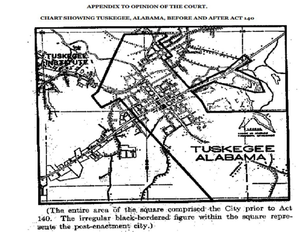
Charles Gomillion went to court to challenge the new boundaries. And the facts he presented prompted a very different response from Justice Frankfurter than with the Illinois map in 1946: “when a legislature thus singles out a readily isolated segment of a racial minority for special discriminatory treatment, it violates the Fifteenth amendment.” That blatant discrimination, Frankfurter argued, distinguished this case from Colegrove, lifting it “out of the so-called ‘political arena’ and into the conventional sphere of constitutional litigation” where the Court could act. And act it did, striking down the map.
Question: is Frankfurter’s effort to distinguish this case from Colegrove that convincing? Is the affirmative act to draw the “new” Tuskegee city boundaries that different from allowing malapportioned districts to emerge by inaction over time? Isn’t the “wrong” inflicted on Black voters similar? Aren’t both cases about the structure of government, something Frankfurter argued in Colegrove that courts should not weigh in on?
As if to signal the door was now open to these questions, within two weeks of handing down Gomillion, the Court accepted a case out Tennessee that would change American politics forever.
3. Baker v. Carr (1962)
If you thought the Illinois map was bad, wait until you see what the Tennessee legislative map looked like after 60 years(!) where all proposals for reapportionment failed to pass…
Keep reading with a 7-day free trial
Subscribe to Pepperspectives to keep reading this post and get 7 days of free access to the full post archives.